![]()
Our firm was founded out of the desire to provide substantial growth opportunities for employees and incentivize them to perform to their highest potential. Our goal is to encourage and reward employees for their achievements. We strive to develop long lasting, honest relationships with our employees and clients.
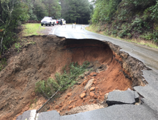
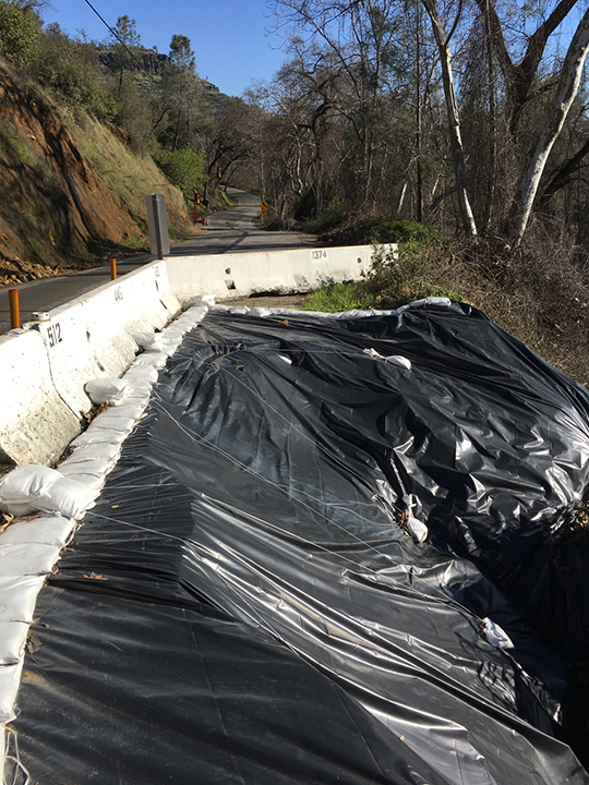
Orr Springs Road (CR 223) Slide at MP 39.20 – Permanent Repair
Mendocino County, California
The subject road failure has resulted in the complete loss of the outboard (west-bound) lane and over half of the inboard (east-bound) lane for a distance of approximately 55 feet and maximum depth of 16 feet.
CAInc prepared a Geotechnical Memo which described the existing site and soil conditions, and analyzed soil samples obtained from test borings. The road failure occurred primarily within residual soil and/or fill material, as well as the uppermost portion of the soft decomposed sandstone. The primary causes of slope failure were due to the inherent weakness of the fill and intensely weathered sandstone, the high degree of saturation from seasonal storm water infiltration during this past very wet winter, and possible internal seepage pressures – including seepage from within the underlying weathered rock.
Recommendations include a soldier pile tieback wall. This option will achieve secure support within the sedimentary rock and provide lateral resistance to active pressures. This option allows for Orr Springs Road (a Major Collector) to remain open during construction, as well as limiting the environmental impact downslope of the failure.
Old Cazadero Road @ PM 17.43 – Geotechnical Investigation
Sonoma County, California
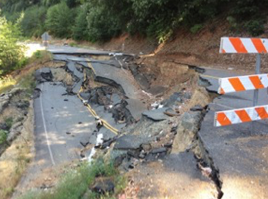
Severe storms in February 2017 resulted in the failure of a 145’ section of the outboard lane. The original 12 ft road width is reduced to about 4’ at the narrowest point. CAInc prepared a Preliminary Site Assessment for Old Cazadero Road. Upon reviewing the site and geologic setting, a preliminary cause of failure was determined to be saturation of weak, unconsolidated fill/colluvium from seasonal storm water infiltration on an over-steepened slope. Runoff from the upslope watershed appeared to collect in the curved section of road at the failure and may have concentrated at this point. The failure appeared to have been a debris-flow type of failure involving mostly the outer fill section and depositing the slide debris about 65 feet below the road (slope distance). CAInc provided preliminary repair alternatives, concluding that a tie-back soldier pile wall to be the best feasible option for the site. Based on the Preliminary Site Assessment, CAInc will prepare a Draft Work Plan detailing the site investigation and a Final Work Plan incorporating any comments by the County and FEMA.
Oro-Quincy Highway
2017 Storm Damage Sites
Butte County, California
Site 1 @ PM 12.1 This road failure has involved both lanes of the highway and closed the road at this location. The failure has affected a 200+ft long section that has dropped about 15 ft vertically and displaced about 10 ft horizontally. CAInc performed a field investigation of three exploratory borings at locations near the slide and performed laboratory testing on the samples. Based on data obtained from the study of the subsurface conditions, CAInc determined material properties and limit-equilibrium analysis and concluded that the failure cause appears to be saturation of the fill, weak “dg” from springs and seasonal storm water infiltration, and discharge from storm drains. Recommendations include installation of subdrainage; excavation of slide debris; key reconstruction section into the “dg” material; excavation of slide material; providing subdrainage relief; replacement of excavated materials; supplement the excavated material with lightweight fill; construct the exterior finish slope at 2:1 (H:V) trimmed to match the adjacent embankment slopes and to buttress the private driveway on the west side; construct and maintain the finished roadway surface such that surface water run-off is diverted away from the embankment slope to prevent erosion; and construct a trenched underdrain along the inner road area to intercept shallow seepage.
Site 2 @ PM 12.6 A section of an existing MSE wall, about 200 feet in length, has settled up to 2-3 feet vertically and about 6” laterally along the highway. CAInc performed a field investigation of six exploratory borings and performed laboratory testing and corrosion tests on the samples. CAInc determined the most likely causes of distress are considered to be settlement of the native soil and “weak” decomposed rock at the base of the existing wall, and possible settlement of the “select granular backfill” within the wall. Recommendations include removal of the MSE wall, backfill, and drain strips within the limits of the roadway distress; drainage of any springs; replacement of excavated soil with new granular fill per Caltrans Standard Specifications; replacement of geocomposite sheet drains; construction of new MSE wall; and construction of new pavement sections.
Centerville Road Storm Damage
Site 1 & Site 2
Butte County, California
Centerville Road has experienced two areas of damage from the January 2017 storms. The first area has affected about a 50 ft section of the north (outboard) lane where two large trees fell into Butte Creek, creating an approximately 8 ft deep hole. The second area is about 200 feet south where the outboard shoulder has eroded/failed along a 50+ft section, including pavement cracking. Both of the failure areas are within a 2-lane section of paved road approximately 20 ft wide.
CAInc prepared an Exploration Summary for both sites. Site exploration included seven test borings and geologic reconnaissance to determine existing subsurface conditions. Preliminary conclusions include:
- Site 1: Proximate cause of roadway distress is primarily due to the adjacent tree falling down, which most likely occurred as a result of the loss of support of the weak/soft near surface soils and underlying rock connected to the tree’s root system. The loss of soil/rock support was likely due to the surface infiltration from the 2017 high seasonal storm events. Subsurface infiltration may have also contributed to the loss of support; however no water springs were observed daylighting on the downslope at the time our explorations were completed.
- Site 2: Proximate cause of roadway distress is likely due to loss of support of the weak/soft near surface soils due to the surface infiltration from the 2017 high seasonal storm events. Subsurface infiltration may have also contributed to the loss of support; however no water springs were observed daylighting on the downslope and groundwater was not encountered within the upper 15 to 18ft at the time our explorations were completed.
CAInc recommended a soldier pile wall for both locations.

El Dorado County Storm Damage Sites
El Dorado County, California
On January 10, 2017, the El Dorado County Board of Supervisors declared a local state of emergency due to damage to County infrastructure from the recent weather events. Several discrete locations were identified where damage to County infrastructure occurred. The County reached out to CAInc to perform preliminary geotechnical assessments and field explorations of the following eight sites as directed by the County:
- String Canyon Road Slipout at PM .44
- Sciaroni Road Slipout
- Pony Express Trail Embankment Failure
- Mosquito Road Culvert Failure at PM 5.25
- Grizzly Flat Road Culvert Separation at PM 7.38
- Cosumnes Mine Road Slipout at PM 2.71
- Cosumnes Mine Road Slipout at PM 2.6
- Cosumnes Mine Road Bridge at North Fork Cosumnes River North Abutment Washout
Rick Sowers and Eric Nichols of Crawford & Associates met with County officials at each site and completed Preliminary Assessments, including preliminary causes of failure, and establish reasonable alternatives to meet the County’s objectives. A Geotechnical Memorandum of Preliminary Assessment was prepared for each site that focused on cost-effective solutions as a basis for the field exploration phase.
For those sites that require Geotechnical Field Exploration, CAInc will conduct the necessary subsurface investigations, laboratory testing and engineering analysis.
")
Alderpoint Road at PM 40.2-40.7
Humboldt County, CA
Prepared a Geotechnical Assessment Letter for the proposed slide repairs at seven sites along Alderpoint Road between Post Miles 40.2 and 40.7.
CAInc reviewed the County’s construction plans, which show a “stab trench” repair for all sites except PM 40.21, which proposes a culvert replacement and inboard underdrain. CAInc also provided observations of each site and provided possible solutions for repair, including “stab trench”, MSE wall, RSP buttress, subdrainage, trenched underdrain, culvert replacement, soldier-pile wall, or rock buttress.
CAInc recommended further study to evaluate the subsurface conditions and confirm/develop the criteria for permanent repair.
Glen Haven Road PM 0.81 Storm Damage
Soquel, Santa Cruz County, CA
Glen Haven Road is a lightly-travelled 20-foot wide paved road that has experienced road failure along a stretch about 35 ft long. There is a residential home located about 50 ft downslope from the slip out scarp that appears to have been damaged by the slope failure.
The failure is predominately an earthflow feature that extends from the road level to the toe located downslope at a horizontal distance of approximately 20 to 30 ft; deposits of the slide debris continues for 20-30 ft further downslope. The failure appears to be mostly confined to the historical fill material above highly weathered to decomposed siltstone.
CAInc prepared a Preliminary Geotechnical Memorandum, which included a description of subsurface conditions and an evaluation of the geologic setting. Based on boring data and site observations, CAInc considered several repair options, including:
- Typical reconstructed embankment with finished slope at 2:1 (horizontal:vertical)
- Reinforced embankment with finished slope of 1.5:1
- Gravity wall system (cribwall, MSE, gabion, etc.)
- Rock slope buttress
- Roadway realignment
- Soldier Pile Wall, traditional construction
- Soldier Pile Wall, low overhead construction
The Soldier Pile Wall option was considered most feasible, and preliminary recommendations were provided for vertical soldier piles, anchor piles, sub-drainage, and backfill.
Jamison Creek Road PM 0.7 Storm Damage
Boulder Creek, Santa Cruz County, CA
Jamison Creek Road is a lightly-travelled 20-foot wide paved road. The road failure has encroached approximately 8 ft into the traveled-way and has failed along a stretch of road about 54 ft long. The failure is predominately a debris feature; the headscarp is approximately 14 ft high (vertically). The failure appears to be mostly confined to the decomposed to very intensely weathered sandstone material.
CAInc prepared a Preliminary Geotechnical Memorandum. Based on boring data and observations of the site, the road failure appears to have occurred primarily within the decomposed to very intensely weathered sandstone material. The primary causes of slope failure appear to be the inherent weakness/thickness of the decomposed to very intensely weathered sandstone and saturation due to the 2016/2017 storm season. The upslope drainage features were likely overwhelmed during the 2016/2017 storm events and allowed significant storm water likely sheet flowed across and infiltrated/saturated the fill material (beneath the road) on an over steepened slope. The swale to the south that appears to deposit stormwater near the toe of the slope likely contributed to slope instability by erode material at the toe.
CAInc considered four repair options, including a Soldier Pile Tieback Wall, Reconstructed Embankment, Gravity wall (e.g. Gabion, Crib), or Combination of Reconstructed Embankment and Gravity wall (e.g. Mechanically Stabilized Earth, Gabion, Crib). Provided preliminary recommendations for two of the options: soldier pile tie-back wall and reconstructed embankment section options.

Jamison Creek Road PM 0.8 Storm Damage
Boulder Creek, Santa Cruz County, CA
Jamison Creek Road is a lightly-travelled 20-foot wide paved road that has experienced road failure along a stretch of approximately 70 ft and it has encroached to about 8 ft of the outboard side of the road. The failure is predominately slump feature.
CAInc prepared a Preliminary Geotechnical Memorandum, which included a description of subsurface conditions and an evaluation of the geologic setting. Based on boring data and site observations, CAInc considered several repair options, including:
- Typical reconstructed embankment with finished slope at 2:1 (horizontal:vertical)
- Reinforced embankment with finished slope of 1.5:1
- Gravity wall system (cribwall, MSE, gabion, etc.)
- Rock slope buttress
- Roadway realignment
- Soldier Pile Wall
The Soldier Pile Wall option was considered most feasible, and preliminary recommendations were provided for vertical soldier piles, sub-drainage, and backfill.
Redwood Lodge Road PM 2.02 Storm Damage
Los Gatos, Santa Cruz County, CA
Approximately 160 to 170 ft of Redwood Lodge Road was damaged during the 2016-2017 storm event and appears to have moved down slope toward Soquel Creek. The failure appears to be mostly confined to the fill soil and the upper portion of previous slide debris. Materials interpreted as fill encountered in borings ranged from approximately 8 to 15 feet thick. Significant free-standing water was observed at the site.
CAInc reviewed the geologic setting and performed five exploratory borings. Based on boring data, CAInc determined that the February 2017 flow displaced fill material and possibly the upper portion of the previous slide zone. Recommendations include a fully-drained, reconstructed embankment.

Bike Path Behind McBride Senior Center
Vacaville, Solano County, California
Severe storms in January 2017 resulted in a slope failure along an approximate 80 ft long section of a path and sacked concrete potion of the subjacent slope. The slope slumped into the creek causing disruption to the sacked concrete section and the failure encroached into the path about 3 to 4 ft for a distance of about 30 ft. The City of Vacaville contracted with CAInc to prepare a Geotechnical Report to provide repair recommendations to restore the pedestrian bike path to its original width.
To prepare the Geotechnical Report, CAInc reviewed site geology and performed a field exploration, which included drilling, logging, and sampling of borings and two portable Dynamic Cone Penetrometer tests to determine approximate soil densities and stiffness. Recommendations for repair options include a flexible gravity-wall-system with reinforced embankment and a soldier pile wall with tie-backs.